Klamath River
| Klamath River (Ishkêesh) | |
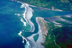
| Link River | |
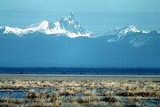
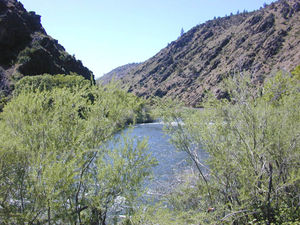 Klamath River in the high desert country of Northern California
|
|
| Name origin: For the Indian tribe called "Klamath" by early 19th-century white travelers[1] | |
| Country | United States |
|---|---|
| States | Oregon, California |
| Tributaries | |
| - left | Shasta River, Scott River, Salmon River, Trinity River |
| City | Klamath Falls |
| Source | Upper Klamath Lake |
| - elevation | 4,090 ft (1,247 m) [2] |
| - coordinates | [3] |
| Mouth | Pacific Ocean |
| - elevation | 0 ft (0 m) |
| - coordinates | [3] |
| Length | 263 mi (423 km) [4][5] |
| Basin | 15,751 sq mi (40,795 km²) [6] |
| Discharge | for near mouth (Klamath, CA) [7] |
| - average | 17,010 cu ft/s (481.7 m3/s) |
| - max | 583,000 cu ft/s (16,508.7 m3/s) |
| - min | 1,340 cu ft/s (37.9 m3/s) |
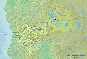 Map of the Klamath River watershed
|
|
The Klamath River (Karuk: Ishkêesh, Klamath: Koke[8]) rises in the southeastern part of the U.S. state of Oregon, and flows about 263 miles (423 km) southwest through California, cutting through the southern Cascade Range to empty into the Pacific Ocean. The river drains an extensive watershed of over 15,000 square miles (39,000 km2) that stretches from the high desert country of the Great Basin to the temperate rainforest of the Pacific coast. It is known for its basin's peculiar geography—most of its upper basin is developed, but the lower remains wild—and has been called "a river upside down" by the National Geographic Society.[9]
One of the most important anadromous fish rivers on the west coast of North America south of the Columbia River, the Klamath River basin has been inhabited by humans for at least 7,000 years. Once, the river supported abundant wildlife and vast freshwater marshes in the upper basin provided habitat for thousands of migratory birds. The first Europeans to visit the region were fur trappers for the Hudson's Bay Company in the 1820s, who established the Siskiyou Trail along the Klamath and Trinity Rivers into the Sacramento Valley. The latter days of the California Gold Rush saw increasing numbers of miners working streams in the Klamath River region in search of gold. Steamboats operated briefly on the large lakes in the upper watershed before the establishment of agriculture in the 19th and 20th centuries. The growing industry in the upper basin led to the construction of many dams on the river, which have since caused water quality issues for the lower river. The dams have caused petitions against the construction of further dams, and to remove the existing ones.
Because the Klamath includes many of the longest free-flowing stretches of river in California as well as some of its better whitewater runs, it has become a popular recreational river. Its watershed includes large swathes of the Klamath National Forest and Six Rivers National Forest. However, time and again, the Klamath has been targeted as a potential water source because of its generous flow, a rarity in most of California. For now, the lower Klamath remains undeveloped, although massive diversions were once proposed to reroute the river into the Central Valley to supplement the region's water supply.
Contents |
Course
Upper Klamath Lake, filling a broad valley at the foot of the eastern slope of the southern High Cascades, is considered the birthplace of the Klamath River. Its headstreams, however, begin over 100 miles (160 km) away—as far as Crater Lake and the Oregon-Nevada border. The first 1-mile (1.6 km) stretch of the Klamath River is known as the Link River. Not long after, however, the river is impounded in a 18-mile (29 km)-long reservoir near Klamath Falls, Lake Ewauna, where it receives the Lost River and passes the nearly-dry bed of Lower Klamath Lake.[10][11][12] Even after it flows out of this reservoir, it drops through a series of three more artificial lakes[13] before it crosses the Oregon-California state border and turns south near the town of Hornbrook towards the direction of Mount Shasta. However, the river soon swings west to receive the Shasta River and Scott River, cutting deep into the head of its canyon through the Klamath Mountains.[5]
The route through the High and Western Cascades and the Klamath Mountains constitutes the majority of the river's course and takes it from the arid high desert climate of its upper watershed into a temperate rainforest nourished by Pacific rains. From the Scott River confluence, the river generally runs west along the south side of the Siskiyou Mountains until it takes a sharp southward turn near the town of Happy Camp. There, it flows southwest over whitewater rapids into the Klamath National Forest, receiving the Salmon River, and passing the unincorporated community of Orleans. At Weitchpec the river reaches the southernmost point in its entire course and veers sharply northwards as it receives the Trinity River. The Trinity River confluence also marks the point where the current of the Klamath slows down dramatically. For the remainder of its course, it flows generally northwest through the Hoopa Valley and Yurok Indian Reservations, passing the town of Klamath and flowing out to sea 16 miles (26 km) south of Crescent City.[10][11]
Watershed
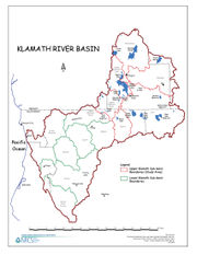
Extending from arid eastern Oregon to the cold and rainy northern California coast, the Klamath River watershed drains parts of three Oregon counties and five counties in California and includes a diversity of landscapes. The northernmost part of the watershed is drained by the Williamson and Sprague rivers which flow generally southwest into Upper Klamath Lake. The middle basin is characterized by extensive wetlands, grassland and agricultural areas, and is partially filled by two major bodies of water: Upper and Lower Klamath Lake. Finally, steep canyons and high ridges typify the extensive lower basin, which encompasses over one half of the 15,751-square-mile (40,790 km2) watershed.[11][14][15]
Several other West Coast and interior drainage basins border on that of the Klamath River. On the northwest are the Rogue River and Umpqua River in Oregon and the Smith River in California. On the east there is the closed Harney Basin and a small portion of the Great Basin. The south side of the Klamath River watershed is bounded by the Sacramento River and its upper tributaries, including the Pit River, and on the southwest side are the Mad River and Redwood Creek.[16] The western boundary of the upper Klamath Basin is formed by the High Cascades, and the Klamath Mountains, one of the southernmost extents of the Cascade Range, and the California Coast Ranges cover the southwestern watershed. The Klamath is one of only a few rivers that begin east of the Cascades and flows into the Pacific Ocean; the others are the Columbia and Fraser.[17]
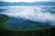
Most human use of the watershed is limited to the upper basin. Despite the semiarid climate, dam-building and irrigation water supplied from the Klamath and Lost rivers and plentiful groundwater have transformed most of the upper Klamath basin to farmland. Once, Lower Klamath and Tule Lakes in the rainy season would combine into one giant freshwater marsh some 195 square miles (510 km2) large. This, combined with the over 100 square miles (260 km2) of Upper Klamath Lake, formed a temporary habitat for millions of migratory birds. These lakes are all remnants of a large Ice Age lake, Lake Modoc, that covered about 1,100 square miles (2,800 km2). Although all of the marshlands have been developed with the exception of Upper Klamath Lake,[18] the region still supports, on average, 3.7 million migrating birds per year.[19]
Despite its plentiful flow and situation in California, the Klamath does not supply significant amounts of water to irrigators and municipal users in central and southern portions of the state. The Klamath Reclamation Project in the Klamath Falls area supplies water to area irrigators, and the Central Valley Project diverts water from the Trinity River to supply irrigation water to the Sacramento Valley.[20] Some of the rivers' tributaries, including the Lost and Shasta Rivers, are also diverted for irrigation. The status of the lower Klamath as one of the last free-flowing rivers in the state of California and the use of its water has been debated for years between preservationists and government agencies and its eventual fate is still unclear.
Geology
The Upper Klamath Basin, defined by the drainage area of the Klamath River above Iron Gate Dam, is a unique transitional area between the Cascade Range to the west and the Basin and Range Province of the northern Great Basin to the southeast. This region extends from the southern Lower Klamath Lake area into the Lost River and Upper Klamath Lake basins. Crustal stretching and block faulting created a topography with characteristics similar to both regions. Almost the entire basin is a graben region, bearing basin and range characteristics, formed by uplifting and subsidence along several north-south faults.[21]
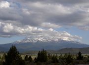
Pre-Quaternary, igneous and sedimentary rock compose the Yonna Formation, which crosses much of the region and rises above the surface in large outcroppings of solid rock in many of the ridges.[22] Underlying rocks are generally younger from east to west. The many ridges crossing the upper Klamath Basin divide it into valleys with up to 330 feet (100 m) of vertical relief, and drainage patterns generally follow the topography. An extensive geothermal system occurs deep underground within the upper basin, creating hot springs and artesian springs, but is not well understood.[23] Further south, in the Shasta River area in Siskiyou County, much of the underlying rock is composed of lava flows issuing from the Mount Shasta volcanic region.[24]
The same age pattern is true in the Cascade Range and Klamath Mountains that cover the western half of the Klamath River watershed. As the North American Plate moved slowly southwestward over the past 10 million years, successive oceanic terranes dating from the Cambrian to the late Jurassic were added to the bulk of the North American continent. There are four distinct terranes from west to east. While the coastal mountains date to less than 3 million years ago, the much more ancient and farther inland High Cascades are as old as 7.5 million years. Granite batholiths, overlying sedimentary rock, and volcanic rock were crumpled into the massif of southwestern Oregon and northwestern California.[25] Instead of being diverted southwards, however, the Klamath continued to flow westward and created a steep-walled gorge through the rising range. One of these terranes brought with it a long north-south running band of easily eroded mica that now lies about 30 miles (48 km) inland from the Pacific coast of northern California.[26][27] When the Klamath encountered this layer, it began cutting its canyon along the mica instead of continuing southwest to the Pacific, resulting in the sharp northward bend where the Trinity River joins. The lower Trinity also follows portions of the mica and its south fork as well.
History
Early inhabitants and settlers
Human habitation on the Klamath dates to at least 7,000 years ago. Many of the Native American groups along the river depended on the vast runs of Pacific salmon, second to only that of the Columbia River. These tribes included the Yurok, Hupa, and Karuk along the canyons of the lower river and the Modoc, Klamath and Yahooskin in the arid valleys of the upper basin. Controlling about 30 miles (48 km) of the lower Klamath River and a large section of the Northern California Pacific coast, the Yurok were probably the most powerful tribe on the Klamath River and along with the Hupa and Karuk, caught salmon from the river with weirs, basket traps and even harpoons.[28][29] One well-known ancient fishing ground is Ishi Pishi Falls, a set of rapids on the river near the confluence with the Salmon River. Most of the upstream groups had a nomadic hunting-gathering lifestyle and did not depend on salmon this much.[30] The Klamath River's name was recorded by Europeans in the 19th century derived from the word klamet or the Klamath tribe, but prior to white contact, many names were used to refer to the river, including Ishkêesh and Koke.
In the late 1820s, fur trappers of the Hudson's Bay Company travelling south from Fort Vancouver reached the Klamath River basin. The first party to see the Klamath River was led by Alexander McLeod in the winter of 1826-1827. Within a matter of years, the plentiful beavers in the Klamath basin had been mostly wiped out. Beaver dams had previously been an important factor in stream habitat in the Klamath River watershed, helping to moderate the power of floods and creating extensive wetlands. This resulted in detrimental consequences for watercourses in the basin, exacerbating the power of winter floods, and causing severe erosion. Trapping parties eventually moved southwest into the Sacramento Valley and established this section of the Siskiyou Trail, an early path between the Oregon Territory and San Francisco Bay. Despite the environmental implications, extensive and fertile meadows left behind by the draining of beaver ponds attracted many settlers to the region later on.[29][31]
The 1850s saw discoveries of rich placer and lode gold deposits along the Klamath, Trinity, Shasta and other rivers in northwestern California. The gold is thought to have originated from volcanic activity in the Klamath Mountains.[32] Miners searching for gold in the Klamath Mountains and Trinity Alps in the aftermath of the California Gold Rush first discovered gold along Salmon Creek in the spring of 1850, and additional deposits were found on the main stem by July. Gold was also discovered in great quantities at French Gulch and Yreka.[33] Several place names in the Klamath Basin originate from this era, including that of the Scott River. Gold deposits are still present in the Klamath River watershed and was mined far past the end of the gold rush.[34]
Klamath River ever since the discovery of gold in its bed has been con-tinuously mined and is still a long way from being worked out. The conditions for river mining in this stream are very favorable. Though carrying a large volume of water, it has nearly everywhere a considerable grade and velocity of current with no great depth......At the present time there are about twenty-five claims being worked on the Klamath and Salmon Rivers, employing three hundred men. Operations in this locality are generally on a small scale and involve the use of but little capital.
-[35]
Early industry and development
_PC_1908.JPG)
Beginning in the early 1900s steamboats began operating on Lower Klamath Lake between Siskiyou County, California, and Klamath Falls, Oregon. The steamboats completed a link between a railroad branch line following the McCloud River - the final part of which was called the Bartle Fast Freight Road, after Bartle, California. The end of this line, Laird's Landing, was the beginning of the Lower Klamath Lake steamboat line, which began operating with an 80-foot (24 m) screw steamer in 1905. By 1909, however, the railroad had circumnavigated Lower Klamath Lake directly to Klamath Falls. The steamboat line fell into disuse—and much of Lower Klamath Lake later was drained and filled in.[36]
In the early 1910s and 1920s logging was a growing industry on the west side of the upper Klamath River valley, especially around Upper Klamath Lake. The Great Northern Railway and Southern Pacific Railroad built a joint-use line running along the eastern shore of the lake, delivering logs from the north side to a sawmill 3 miles (4.8 km) downstream from the outlet of the lake. Many of the seasonal marshlands surrounding the lake and rivers were diked in this period to host lumber operations.[37] In 1919, the first Link River Dam, a timber crib dam, was constructed at the outlet of Upper Klamath Lake, raising it by about 16 feet (4.9 m). Steamboats continued mail, passenger and freight operations on Upper Klamath Lake until about 1928, in a period when many of the lumber companies shut down.[38]
With lumber a declining industry in the upper Klamath Basin, the economy slowly transitioned to agriculture. The Klamath Reclamation Project, established by the Bureau of Reclamation in the early 20th century, involved the construction of two dams on the river and additional dams on many of its tributaries, as well as the final draining of Lower Klamath and Tule Lakes. The Bureau of Reclamation was not the only user of the river during this period; in the late 1950s PacifiCorp and California-Oregon Power Company (Copco) constructed three more dams on the river downstream. These dams, however, sparked a great controversy over water quality in the lower section of the river and the dependence of the river's annual salmon runs on it.
Salmon controversy
The remaining water left in the river, whatever the Project is willing to release from Iron Gate Dam, is so little in volume, so hot and so laced with pesticides and nitrates from agricultural waste water that it is often fatal for salmon as much as 100 miles downriver. Hundreds of thousands of salmon have been killed in recent years as a result, and Klamath River coho salmon driven nearly to extinction.[39]
-Pacific Coast Federation of Fishermen's Associations
Historically, the Klamath River was once the "third most productive salmon river system in the United States", after the Columbia and the Sacramento.[39] Eutrophication and raised water temperatures induced by the construction of dams have created worsening conditions for migrating salmon, especially in years of drought.[40][41][42] The upper basin water, along with the almost-total diversion of the Trinity,[43] as well as irrigation projects on the Shasta and Scott river tributaries have all lowered the total river flow supporting out-migrating young salmon in spring and in-migrating adult salmon in the fall.[44] In the 1960s, a project was proposed to divert the entire Klamath River to central and southern California, an undertaking known as the Klamath Diversion, but was defeated. This would have limited salmon to the last 12 miles (19 km) of the entire river.[45] In 2005, PacifiCorp applied to the federal government to relicense its four hydroelectric dams on the Klamath for up to 50 years. Environmentalists opposed the relicensing, arguing that they should be removed to reopen the upper Klamath to salmon.[46]
An agreement was signed February 18, 2009.[47] Two years of closed-door negotiations among farmers, Indian tribes, fishermen, conservation groups and government agencies have resulted in an unprecedented—and conditional—agreement to work toward a comprehensive settlement of Klamath water usage. The proposal advocates for the removal of four hydroelectric dams now operating along 300 miles (483 km) of the Klamath River in southern Oregon and northern California, as well as resortation projects.[48] A nonbinding "Agreement in Principle" (AIP) involving PacifiCorp, the Federal Government, California and Oregon was announced November 13, 2008. It is the initial phase of a process, which, could see the removal of Iron Gate Dam, Copco dams number 1 and 2, and John C. Boyle Dam, beginning by the year 2020. PacifiCorp rate payers would fund part of the plan and the State of California would fund much of the remaining projected cost. The agreement requires the federal government to scientifically assess the costs and benefits of the dam removals, and to make a final determination by March 31, 2012 as to whether the benefits of the project will justify the costs. Federal Congressional and California electorate approval also is required.[49]
Recreation
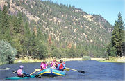
Whitewater rafting and kayaking are popular recreational activities along the upper Klamath River below the J.C. Boyle Dam, and also along the lower Klamath River downstream of the town of Happy Camp. There are long stretches, over 100 miles (160 km) in one instance, of Class I-II whitewater rapids, while there are some Class III-IV rapids in some of the narrower stretches. Below Weitchpec, the river slows down into a wider, deeper channel. 13 miles (21 km) of the river is designated Wild, and 175 miles (282 km) Recreational.[50]
Recreational gold mining is popular along the Klamath and some of its tributaries, including the Salmon and Trinity. Although simple methods such as panning are still used, some methods use suction pumps—a practice involving turning over deposits of sediment and spreading them in order to find gold. Debates over the practice, which has further disturbed salmon spawning beds, continue to date.[51]
A variety of national forests and wildlife preserves—including the Klamath National Forest, Six Rivers National Forest, Klamath National Wildlife Refuges Complex, and Lower Klamath National Wildlife Refuge—are located in the Klamath River watershed. The Klamath National Forest is located in Siskiyou County with a small portion in Oregon, and Six Rivers National Forest is located in the southern Klamath watershed mostly in the Trinity River watershed. The latter two are located in the Upper Klamath Lake - Lower Klamath Lake area. Lava Beds National Monument, which contains a large array of lava tubes and formations, is also in the Lower Klamath Lake area to the south of the remnants of the lake.
Natural history
The river is considered a prime habitat for Chinook salmon, Coho salmon, steelhead trout, and rainbow trout. Once the third-largest producer of salmon on the West Coast,[39] only a fraction of the river's historic runs remain since the construction of six dams, built between 1908 and 1962. Coho salmon in the Klamath River are listed as threatened under the U.S. Endangered Species Act. In 1963 the largest single tributary to the Klamath, the upper Trinity River, was virtually removed from the Klamath drainage with the completion of the Lewiston and Trinity Dams, diverting 90 percent of the Trinity's flow to the Sacramento Valley. Only 150 cubic feet (4.2 m3) per second from the main stem above the dams was left to flow to the Klamath. In 1991, a minimum annual Trinity flow of 340,000 acre feet (420,000,000 m3) was established, or about 470 cubic feet per second (13 m3/s).[43]
The possible removal of the dams has been a controversial issue in the region in recent years. Despite intense lobbying by local Native American tribes, conservationists, and fishermen, the 2004 renewal application by PacifiCorp for another 50-year federal operating licence for the dams did not include any provisions for allowing salmon to return to more than 300 miles (483 km) of former habitat above the dams. In January 2007, however, the federal government ruled that PacifiCorp must equip four dams with fish ladders, a modification which would cost potentially more than $300 million. PacifiCorp has offered $300 million to upgrade the JC Boyle fish ladder and proposed trucking fish around the Copco #1 and Iron Gate dams, after having had been denied a licence to build a power generator in Utah. "The fact that the Klamath project is an emissions-free, renewable resource will make it more valuable to our customers in the future and reduce our overall carbon footprint," PacifiCorp President Fehrman said in a statement.[52]
A separate controversy surrounds the use of water in the Upper Klamath Basin for irrigated agriculture, which was temporarily halted in 2001 to protect endangered salmon and lake fish during a severe drought. The federal government, under Interior Secretary Gale Norton, reversed this decision in 2002, and provided full water deliveries to irrigators as the drought continued despite the fact that Klamath area tribes have treaty rights that predate the settlement of the farmers. Norton argued for a "free market" approach by allowing farmers to sell the water to the Native Americans downstream.[53][54]
According to biologists from the state of California and the U.S. Fish and Wildlife Service,[55] the atypical low flow in the river along with high fish return numbers and high water temperatures allowed for a gill rot disease to kill at least 33,000 salmon in September 2002, which died before they could reproduce. The kill was downstream of the Trinity inflow, and the salmon of the Trinity were impacted to a greater degree than the Klamath as the Trinity run was at its peak. The report does mention that the official fish kill estimate of 34,056 is probably quite low and could be only half of the actual loss. Klamath River flows as measured at the river gauge in Keno show a low flow of 800 cubic feet (22.7 m3) per second in September 1908 (before irrigation began). During the 2002 fish kill, flows of 475 cubic feet (13.5 m3) per second were recorded. During September of the 2001 irrigation shut off, an average of 688 cubic feet (19.5 m3) per second was recorded.[56]
Tributaries
- Blue Creek
- Boise Creek
- Trinity River
- South Fork Trinity River
- New River
- Copper Creek
- Salmon River
- Scott River
- Shasta River
- Butte Creek
- Lost River
- Sprague River
- Williamson River
See also
- Course of the Klamath River
- Klamath Basin
- List of California rivers
- List of Oregon rivers
- List of National Wild and Scenic Rivers
References
Notes
- ↑ McArthur, Lewis A.; McArthur, Lewis L. (2003). Oregon Geographic Names, Seventh Edition. Portland, Oregon: Oregon Historical Society Press. pp. 541–42. ISBN 0-87595-277-1.
- ↑ Google Earth elevation for source coordinates
- ↑ 3.0 3.1 U.S. Geological Survey Geographic Names Information System: Klamath River, USGS, GNIS
- ↑ "Klamath Basin: A Watershed Approach to Support Habitat Restoration, Species Recovery, and Water Resource Planning" (PDF). U.S. Geological Survey. http://wfrc.usgs.gov/pubs/factsheetpdf/kbawsafs080807.pdf. Retrieved 2008-06-29.
- ↑ 5.0 5.1 "Klamath River Basin Issues and Activities: An Overview" (PDF). California Department of Energy. http://www.energy.ca.gov/klamath/documents/CRS_REPORT_RL33098.PDF. Retrieved 2008-06-29.
- ↑ "Work Plan for Adaptive Management in the Klamath Basin" (PDF). Natural Resources Conservation Service, United States Department of Agriculture. 2004. http://www.nrcs.usda.gov/feature/klamath/images/AMPMay19_2004.pdf.
- ↑ "Water Resources Data—California, Water Year 2004" (PDF). Volume 2. U.S. Geological Survey. http://pubs.usgs.gov/wdr/2004/wdr-ca-04-2/WDR.CA.04.vol2.pdf.
- ↑ McArthur, p. 542
- ↑ "Reuniting a River: After fighting for years over its water, farmers, Indians and fishermen are joining forces to let the troubled Klamath River run wild again". National Geographic Society. National Geographic Magazine. 2008-12. http://ngm.nationalgeographic.com/print/2008/12/klamath-river/rymer-text. Retrieved 2009-08-21.
- ↑ 10.0 10.1 "Klamath River Dam and Sediment Investigation". Yurok Tribe of California. www.yuroktribe.org. November 2006. http://www.yuroktribe.org/departments/fisheries/documents/GECFinalReport.pdf. Retrieved 2009-08-21.
- ↑ 11.0 11.1 11.2 Hydrology, Ecology and Fishes of the Klamath River Basin, p.27
- ↑ "Ground-Water Hydrology of the Upper Klamath Basin, Oregon and California". Scientific Investigations Report 2007–5050. U.S. Geological Survey. http://pubs.usgs.gov/sir/2007/5050/section2.html. Retrieved 2008-06-29.
- ↑ "Klamath River, Oregon and California". American Rivers. http://www.americanrivers.org/our-work/restoring-rivers/dams/projects/restoring-klamath-river.html. Retrieved 2009-08-21.
- ↑ Hydrology, Ecology and Fishes of the Klamath River Basin , p. 26
- ↑ "Klamath River Basin - Overview". United States Department of Agriculture Natural Resources Conservation Service. www.nrcs.usda.gov. http://www.nrcs.usda.gov/feature/klamath/klambasin.html. Retrieved 2009-08-21.
- ↑ Commission for Environmental Cooperation (CEC). Watersheds [map]. Cartography by CEC, Atlas of Canada, National Atlas, Instituto Nacional de Estadística y Geografía. Retrieved 2009-10-08.
- ↑ The Columbia River rises in the Rocky Mountain Trench of the Canadian Rockies several hundred miles east of the Cascades, while the Fraser begins in the Rocky Mountain Trench farther north. Both rivers cut through the Cascades to flow to the Pacific Ocean (In the case of the Fraser, the mountains there are called the Canadian Cascades, but geophysically they are part of the same range.) The Klamath’s uppermost tributaries begin just to the northwest of the Great Basin, well to the east of the High Cascades. Rivers like the Rogue and Umpqua in Oregon that cut through the Coast Range and begin on the western slopes of the High Cascades should not be confused as cutting through the Cascades although they do flow through the parallel range.
- ↑ "Klamath Lake". Oregon Lakes Association. http://www.oregonlakes.org/gallery/klamath/klamath.html. Retrieved 2009-08-21.
- ↑ Balancing water: restoring the Klamath Basin, p. 1
- ↑ "Shasta/Trinity River Division Project". U.S. Bureau of Reclamation. http://www.usbr.gov/projects/Project.jsp?proj_Name=Shasta/Trinity%20River%20Division%20Project. Retrieved 2009-08-21.
- ↑ "Upper Klamath Basin Groundwater Study". Oregon Water Science Center. U.S. Geological Survey. http://or.water.usgs.gov/projs_dir/or180/background.html. Retrieved 2009-11-10.
- ↑ Newcomb, R. C. (1958). "Yonna Formation of the Klamath River, Oregon". U.S. Geological Survey. Washington State University. http://www.vetmed.wsu.edu/org_nws/NWSci%20journal%20articles/1950-1959/1958%20vol%2032/vol2%20p41%20Newcomb.pdf. Retrieved 2009-11-11.
- ↑ "Klamath Falls Geologic Map Project". Oregon Department of Geology and Mineral Industries. http://www.oregongeology.org/sub/FIELDOFFICES/George/KlamathFalls.htm. Retrieved 2009-11-11.
- ↑ "Upper Klamath River 8-Digit Hydrologic Unit Profile". Natural Resources Conservation Service. U.S. Department of Agriculture. 2006-02. ftp://ftp-fc.sc.egov.usda.gov/OR/HUC/basins/highdesert/18010206_2-23-06.pdf. Retrieved 2009-11-11.
- ↑ Snoke, Arthur, ed. (2006) Geological Studies in the Klamath Mountains Province, California and Oregon, p. 289
- ↑ Snoke (2006) Geological Studies in the Klamath Mountains province, California and Oregon, p. 16
- ↑ Covington, Sid (2004-04-20). "Whiskeytown National Recreation Area Geologic Resources Management Issues Scoping Summary". Geologic Resources Division. U.S. National Park Service. http://www.nature.nps.gov/geology/inventory/publications/s_summaries/WHIS_scoping_summary_20041025.pdf. Retrieved 2009-11-11.
- ↑ Pasek, Laura. "Yurok". Minnesota State University, Mankanto. http://www.mnsu.edu/emuseum/cultural/northamerica/yurok.html. Retrieved 2009-08-21.
- ↑ 29.0 29.1 Sabrina Litton (Spring 2003). "A Review of the History of Water Use throughout the Klamath River Basin". Center for Watershed Sciences. University of California Davis. http://watershed.ucdavis.edu/scott_river/docs/reports/Sabrina_Litton.pdf. Retrieved 2010-05-19.
- ↑ Darling, Dylan (19 June 2005). "Your land, my land? (page 1)". Herald and News. http://www.heraldandnews.com/articles/2005/06/19/breaking_news/breaking1.txt. Retrieved 2009-08-21.
- ↑ Mackie, Richard Somerset (1997). Trading Beyond the Mountains: The British Fur Trade on the Pacific 1793-1843. Vancouver: University of British Columbia (UBC) Press. pp. 66. ISBN 0-7748-0613-3.
- ↑ Hittell, p. 141
- ↑ "Gold Mines and Gold Prospecting in California - Region 6". goldmaps.com. http://goldmaps.com/calif/california_gold_mines_6.htm. Retrieved 2009-08-22.
- ↑ Hall, Monica; Jenner, Gail. "Early Gold Mining on the Trinity and Klamath Rivers". Klamath Bucket Brigade. http://www.klamathbucketbrigade.org/PioneerPress_EarlyGoldMiningontheTrinityandKlamathRivers071509.htm. Retrieved 2009-08-22.
- ↑ Ninth Annual Report of the State Mineralogist, 1889Dunn, R.L.. "River Mining". Ninth Annual Report of the State Mineralogist for the year ending December 1, 1889. http://www.goldledge.com/history/docs_html/river_mineralogists_report.html. Retrieved 2009-08-22.
- ↑ "Steamboats on Klamath Lake". Siskiyou County History. www.siskiyouhistory.org. http://www.siskiyouhistory.org/1900_story1.html. Retrieved 2009-08-21.
- ↑ Balancing water: restoring the Klamath Basin, p. 9
- ↑ Boyle, John C.. "Regulation of Upper Klamath Lake". Klamath Bucket Brigade. http://www.klamathbucketbrigade.org/regulation_of_upper_klamath_lake.htm. Retrieved 2009-08-21.
- ↑ 39.0 39.1 39.2 "The Struggle to Save Salmon in the Klamath Basin". The Pacific Coast Federation of Fishermen's Associations. http://www.pcffa.org/klamath.htm. Retrieved 2009-08-21.
- ↑ Endangered and threatened fishes in the Klamath River Basin: causes of decline and strategies for recovery. National Academies Press. 2004. p. 263. ISBN 9780309090971. http://books.google.com/books?id=ce8KOtWDv4wC&printsec=frontcover&dq=Endangered+and+threatened+fishes+in+the+Klamath+River+Basin:+causes+of+decline+and+strategies+for+recovery&source=bl&ots=sODyq1bMAA&sig=vk34xox8AHXRP2sFdTsM5pLCSoM&hl=en&ei=cNn0S5-iGYqktgPj9byIBQ&sa=X&oi=book_result&ct=result&resnum=3&ved=0CCMQ6AEwAg#v=onepage&q=salmon&f=false. Retrieved May 19,2010.
- ↑ Foster, Doug (2002). "Refuges and Reclamation: Conflicts in the Klamath Basin" (PDF). Oregon Historical Quarterly. Oregon Historical Society. http://oregonwild.org/rivers_clean_water/restoring_balance_klamath_basin/klamath-reports-and-science/OHQ1032_Foster.pdf. Retrieved 2008-06-29.
- ↑ "Restoring Balance to the Klamath Basin". Oregon Wild. http://www.oregonwild.org/rivers_clean_water/restoring_balance_klamath_basin. Retrieved 2008-06-29.
- ↑ 43.0 43.1 "Central Valley Project:Trinity River Division". U.S. Bureau of Reclamation History Program. 1994. http://www.usbr.gov/dataweb/html/trinity.html. Retrieved 2008-06-29.
- ↑ "Klamath Project". U.S. Bureau of Reclamation. http://www.usbr.gov/dataweb/html/klamath.html. Retrieved 2008-06-29.
- ↑ Reisner, pp.267-268
- ↑ Whitney, David (2007-08-12). "Discord threatens Klamath River water talks: Refuge farms "a deal-killer"". Sacramento Bee. http://www.sacbee.com/111/story/321042.html.
- ↑ "Klamath Basin Deal Helps Farmers, Fish". KPTV. February 18, 2010. http://www.kptv.com/money/22603281/detail.html. Retrieved 2010-02-18.
- ↑ "Proposed Klamath River Basin Restoration Agreement for the Sustanability of Public and Trust Resources and Affected Communities" (PDF). 2008-01-15. http://www.edsheets.com/Proposed%20Klamath%20Basin%20Restoration%20Agreement%20%20January%2015,%202008%20(Draft%2011).pdf. Retrieved 2008-06-29.
- ↑ "Historic Dam Removal Decision". Mt. Shasta News. http://www.mtshastanews.com/news/x1720661209/-Historic-dam-removal-decision.
- ↑ Palmer, p. 141
- ↑ Bacher, Dan (Tuesday, 24 March 2009). "Klamath RiverKeeper Joins Suit to Stop Harmful Recreational Gold Mining". Klamath RiverKeeper. www.columbia.org. http://www.columbia.org/pdf_files/klamath.pdf. Retrieved 2009-08-22.
- ↑ Barnard, Jeff (February 10, 2007). "PacifiCorp willing to build fish ladders". Associated Press. http://www.triplicate.com/news/story.cfm?story_no=2672. Retrieved 2008-06-29.
- ↑ "The Truth About Klamath Project Irrigation Water Deliveries in 2001". Klamath Basin Coalition Fact Sheet. Klamath Basin Coalition. 2003-05-15. http://www.klamathbasin.info/2001waterfacts.pdf. Retrieved 2009-11-12.
- ↑ Taylor, James M. (2002-02-01). "NAS panel investigates Klamath water shutoff". Environment and Climate News. Heartland Institute. http://www.heartland.org/publications/environment%20climate/article/572/NAS_panel_investigates_Klamath_water_shutoff.html. Retrieved 2009-11-12.
- ↑ "September 2002 Klamath River Fish-Kill: Final Analysis of Contributing Factors and Impacts". Pacific Coast Federation of Fishermen's Associations. www.pcffa.org. July 2004. http://www.pcffa.org/KlamFishKillFactorsDFGReport.pdf. Retrieved 2009-08-23.
- ↑ "USGS Gage #11512500 on the Klamath River below Fall Creek near Copco (Average Annual Streamflow)". National Water Information System. United States Geological Survey. 2 January 1924 to 1 December 1960. http://nwis.waterdata.usgs.gov/nwis/annual?site_no=11512500&por_11512500_1=2210277,00060,1,1924,1961&year_type=W&format=html_table&date_format=YYYY-MM-DD&rdb_compression=file&submitted_form=parameter_selection_list. Retrieved 2009-08-23.
Works cited
- Irwin, William Porter; Snoke, Arthur W.; Barnes, Calvin G. (2006). Geological studies in the Klamath Mountains. Geological Society of America. ISBN 0813724104.
- Board on Environmental Studies and Toxicology (BEST); Water Science and Technology Board (WSTB), 2008. Hydrology, Ecology and Fishes of the Klamath River Basin. National Academies Press.
- Reisner, Marc. Cadillac Desert. Penguin Books.
- Palmer, Tim (1993). The wild and scenic rivers of America. Island Press. ISBN 1-55963-145-7.
- National Research Council (NRC, 2004). Endangered and threatened fishes in the Klamath River Basin: causes of decline and strategies for recovery. National Academies Press. ISBN 0-309-09097-0.
- McArthur, Lewis L. (2003). Oregon geographic names. Oregon Historical Society Press. ISBN 0-87595-277-1.
- Blake, Tupper Ansel; Blake, Madeleine Graham; Kittredge, WIlliam (2000). Balancing water: restoring the Klamath Basin. University of California Press. ISBN 0-520-21314-9.
- U.S. Coast and Geodetic Survey (UCGS, 1951). United States Coast Pilot. University of California.
- Hittell, Theodore Henry (1897). History of California, Volume 3. N.J. Stone.
External links
- Klamath RiverKeeper
- Mid Klamath Watershed Council
- State of California hydrological monitoring of the Klamath and tributaries.
- NASA Earth Observatory: drought and irrigation shut off in the Klamath Basin
- Spot.us - Story: The Story Behind the World's Biggest Dam Removal - Rough Water
|
||||||||||||||||||||||